Cyclonic storm GAJA to move closer to northern coast today
November 15, 2018 08:11 am
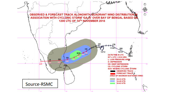
The Cyclonic storm ‘GAJA’ over the Central Bay of Bengal is very likely to intensify into a Severe Cyclonic Storm and move closer to the northern coast of Sri Lanka during today (November 15) evening, the Department of Meteorology warned.
The Cyclonic storm is now located approximately 510km away from Kankasanturai to the northeast of Sri Lanka, near latitude-12.2N, Longitude-84.0E at 8.30 p.m. on November 14.
Issuing a special weather advisory for strong winds, heavy rain and rough seas, the department said it is very likely to move west southwestwards and intensify further into a Severe Cyclonic Storm during next 06 hours.
The system is expected to cross South Tamil Nadu coast and very likely to move closer to the northern coast of Sri Lanka during today evening.
LAND AREA:
Under the influence of this system showery and windy condition will enhance over the Northern and North-central provinces and in the Puttalam and Trincomalee districts during 14th evening to 15th November 2018.
High winds (80 - 90) kmph, gusting up to 100kmph can be expected over the Jaffna peninsula from today (15) evening.
Very strong winds (60-70) kmph, gusting up to 80kmph can be expected over Mannar, Puttalam, Trincomalee, Anuradhapura, Polonnaruwa, Killinochchi, Mullaitiv and Vauniya districts too.
Showers and thundershowers at times with Very heavy falls above 150mm can be expected in the Jaffna peninsula. Heavy falls above 100mm can be expected in other areas in the Northern Province.
Sea water inundation may occur in the low lying areas in the near coast from Mannar to Kankasanturai.
SEA AREA:
High winds (80 - 90) kmph, gusting up to 110kmph can be expected over the sea areas off the coast extending from Mullaitivu to Mannar via Kankasanturai will be very rough from 14th noon to 16th November.
The sea areas off the coast extending from Potuvil to Mullaitivu via Batticaloa can be rough at times as the wind speed can increase up to (50-60) kmph.
Heavy showers or thundershowers can be expected in the sea areas off the coast extending from Mullaitivu to Mannar via Kankasanturai.
Fishermen are advised not to venture into sea areas off coast extending from Potuvil to Mannar via Trincomalee and Kankasanturai.
The fishermen, who are in deep Sea of South-west Bay of Bengal, are advised to move safer sea areas.