SL maritime boundary mapping program begins today

SL maritime boundary mapping program begins today

October 26, 2017   11:16 am

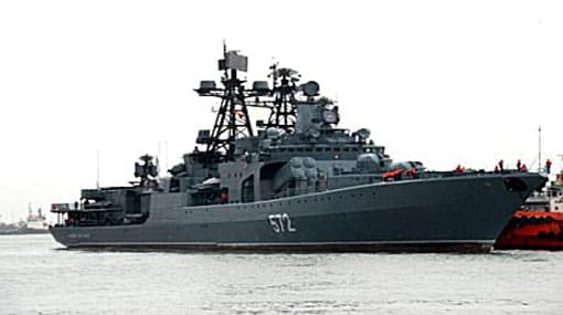
The second phase of Sri Lanka’s maritime boundary mapping program begins today (26) as a joint venture of the Sri Lanka Navy and the Indian Navy.

Media Coordinator for the SL Navy Commander Lankanatha Dissanayake stated that the measuring program of the second phase will continue till December 21. 

He also stated that the southern and western coastal regions of Sri Lanka will be demarcated through the program.   

The initial phase was conducted in May 2016, with the aid of an Indian naval vessel that assisted in the mapping process. It has been reported that the same vessel will be used for the second phase of the project. 

Disclaimer: All the comments will be moderated by the AD editorial. Abstain from posting comments that are obscene, defamatory or slanderous. Please avoid outside hyperlinks inside the comment and avoid typing all capitalized comments. Help us delete comments that do not follow these guidelines by flagging them(mouse over a comment and click the flag icon on the right side). Do use these forums to voice your opinions and create healthy discourse.

Most Viewed Video Stories

'NPP govt is a govt for the people' - President tells new LG members (English)

'NPP govt is a govt for the people' - President tells new LG members (English)

Cases of dengue and chikungunya on the rise, Dy Health Minister (English)

Second-year student at Wayamba National College of Education commits suicide in hostel (English)

🔴LIVE | Ada Derana Prime Time News Bulletin | 2025.05.25

LIVE🔴 Ada Derana Lunch Time News Bulletin 12.00 pm

Ex-Minister Duminda Dissanayake remanded over 'gold-plated' T-56 firearm (English)

Govt. has no intention of acquiring lands from people in North and East under any circumstances – PM (English)

Sri Lankan delegation to engage in tariff talks in Washington DC (English)