


The Asian Institute of Technology’s Geoinformatics Center (GIC) has prepared dynamic emergency response maps in response to the Sri Lanka floods that have affected 15 districts in the island nation.
The data viewer combines satellite imagery with real-life photographs and incorporates river water levels, and data on loss and fatalities to provide an overview of the extent of the floods.
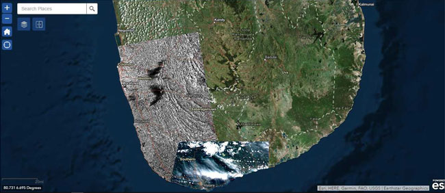
While traditional disaster maps are static and are often solely based on satellite data and its interpretation, this emergency data viewer enables a more powerful and dynamic visual interpretation adding value for disaster relief and emergency responders.
“Traditional maps are often restricted in their usability since they provide static information, while the combination of imagery, flood levels, and ground-level information vastly enhances the usability of this data viewer,” says Dr. Manzul Kumar Hazarika, Director (Project Operations), Geoinformatics Center, AIT.
An estimated 200 people have died, and over half a million have been displaced in Sri Lanka, according to news reports as of 1 June 2017.
Data for this exercise was obtained from a variety of sources. The water levels have been obtained from the Sri Lankan Department of Irrigation, and they have been graded according to their alert levels — normal, alert level and major flood levels. Four types of satellite imagery has been used — ALOS-2, RADARSAT-2, Sentinel 2, and TerraSAR-X. The photo gallery is crowd-sourced and it has been developed for the Disaster Management Center of Sri Lanka by GIC.
Data sources tapped for this exercise include Sentinel Asia, Japan Aerospace Exploration Agency (JAXA), European Space Agency (ESA), Canadian Space Agency (CSA), German Aerospace Centre (DLR), and the International Water Management Institute (IWMI); while aerial photo sources are Climate Resilience Improvement Project (CRIP), World Bank Group, Asia Pacific Alliance, and Disaster Management Centre, Sri Lanka.
The Data Viewer can be accessed here:
https://gicait.maps.arcgis.com/apps/MapSeries/index.html?appid=f1ea1aa639614a18893224a363905c84